CASE STUDY
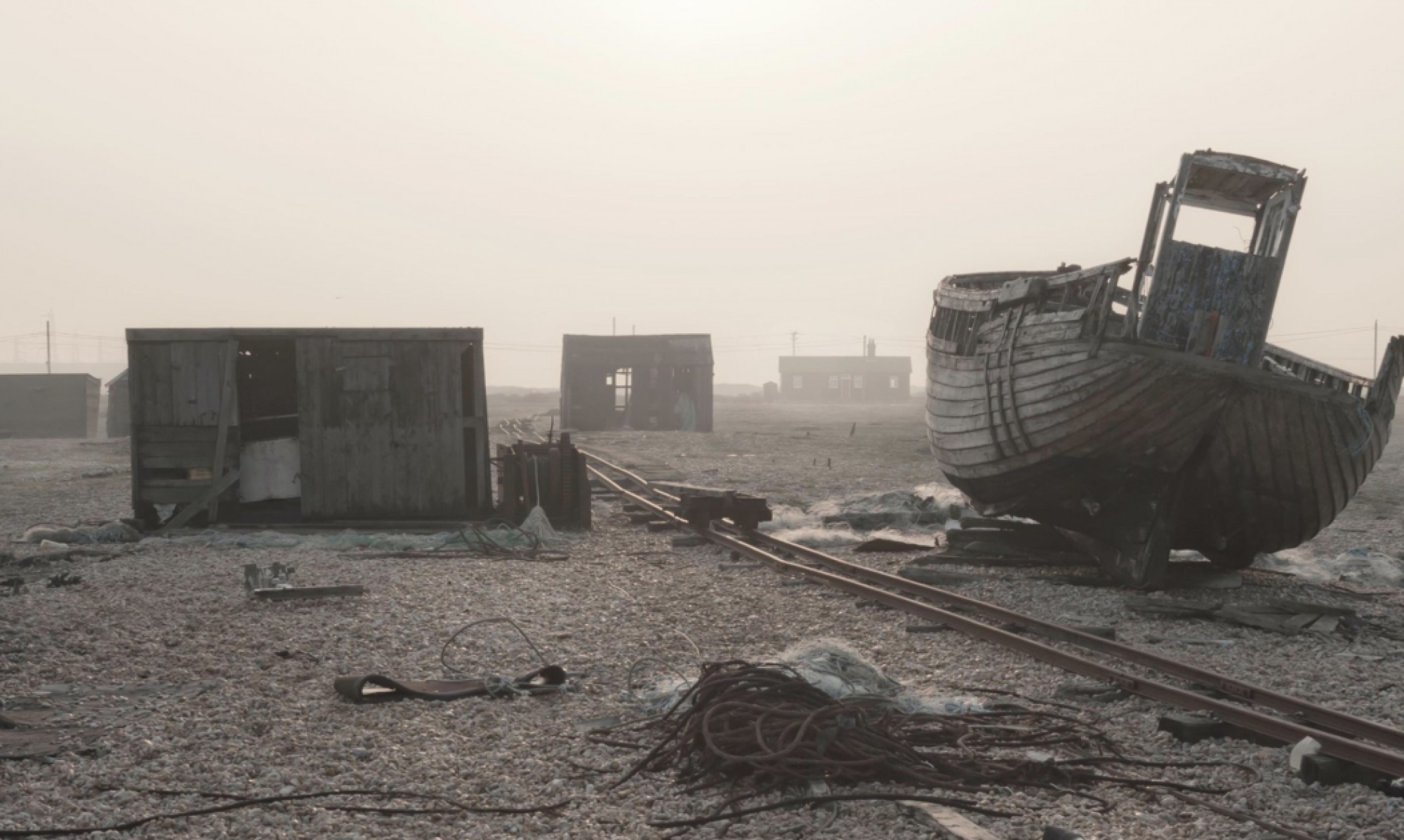
Priozersk (formally known as ‘Moscow 10’) and Kurchatov are ‘closed cities’, restricted military zones, concealed and not shown on maps until they were ‘discovered’ by Google Earth. Enlisted to the pursuits of science and war, the sites were used for the covert testing of atomic and long distance weapons.
Falsely claimed as uninhabited, the cities, along with nearby testing site ‘The Polygon’ set the stage for one of the most cynical experiments ever undertaken. Scientists watched and silently documented the horrifying effects of radiation and pollution on the local population and livestock.
The Semipalatinsk Test Site (Russian: Семипалатинск-21; Semipalatinsk-21), also known as “The Polygon“, was the primary testing venue for the Soviet Union’s nuclear weapons. It is located on the steppe in northeast Kazakhstan (in the former Kazakh SSR), south of the valley of the Irtysh River. The scientific buildings for the test site were located around 150 km (93 mi) west of the town of Semipalatinsk, later renamed Semey, near the border of East Kazakhstan Region and Pavlodar Region. Most of the nuclear tests taking place at various sites further to the west and the south, some as far as into Karagandy Region.
The Soviet Union conducted 456 nuclear tests at Semipalatinsk from 1949 until 1989 with little regard for their effect on the local people or environment. The full impact of radiation exposure was hidden for many years by Soviet authorities and has only come to light since the test site closed in 1991 . According to estimates from Kazakh experts, 1.5 million people were exposed to fallout over the years.
From 1996 to 2012, a secret joint operation of Kazakh, Russian, and American nuclear scientists and engineers secured the waste plutonium in the tunnels of the mountains.
Since its closure on 29 August 1991, the Semipalatinsk Test Site has become the best-researched nuclear testing site in the world, and the only one in the world open to the public year-round.
HISTORY
The site was selected in 1947 by Lavrentiy Beria, political head of the Soviet atomic bomb project. Beria falsely claimed the vast 18,000 km² steppe was “uninhabited”. Gulag labour was employed to build the primitive test facilities, including the laboratory complex in the northeast corner on the southern bank of the Irtysh River. The first Soviet bomb test, Operation First Lightning, nicknamed Joe One by the Americans, was conducted in 1949 from a tower at the Semipalatinsk Test Site, scattering fallout on nearby villages, which Beria had neglected to evacuate. The same area, “the experimental field”, a region 64 km (40 mi) west of Kurchatov city, was used for more than 100 subsequent above-ground weapons tests.
Later tests were moved to the Chagan River complex and nearby Balapan in the east of the STS, including the site of the Chagan test, which formed Chagan Lake. Once atmospheric tests were banned, testing was transferred to underground locations at Chagan, Murzhik in the west, and at the Degelen mountain complex in the south, which is riddled with boreholes and drifts for both subcritical and supercritical tests. After the closure of the Semipalatinsk labour camp, construction duties were performed by the 217th Separate Engineering and Mining Battalion, who later built the Baikonur Cosmodrome.
Between 1949 and the cessation of atomic testing in 1989, 456 explosions were conducted at the STS, including 340 underground borehole and tunnel shots and 116 atmospheric, either air-drop or tower shots. The lab complex, still the administrative and scientific centre of the STS, was renamed Kurchatov City after Igor Kurchatov, leader of the initial Soviet nuclear programme. The location of Kurchatov city has been typically shown on various maps as “Konechnaya”, the name of the train station, now Degelen, or “Moldary”, the name of the village that was later incorporated into the city.
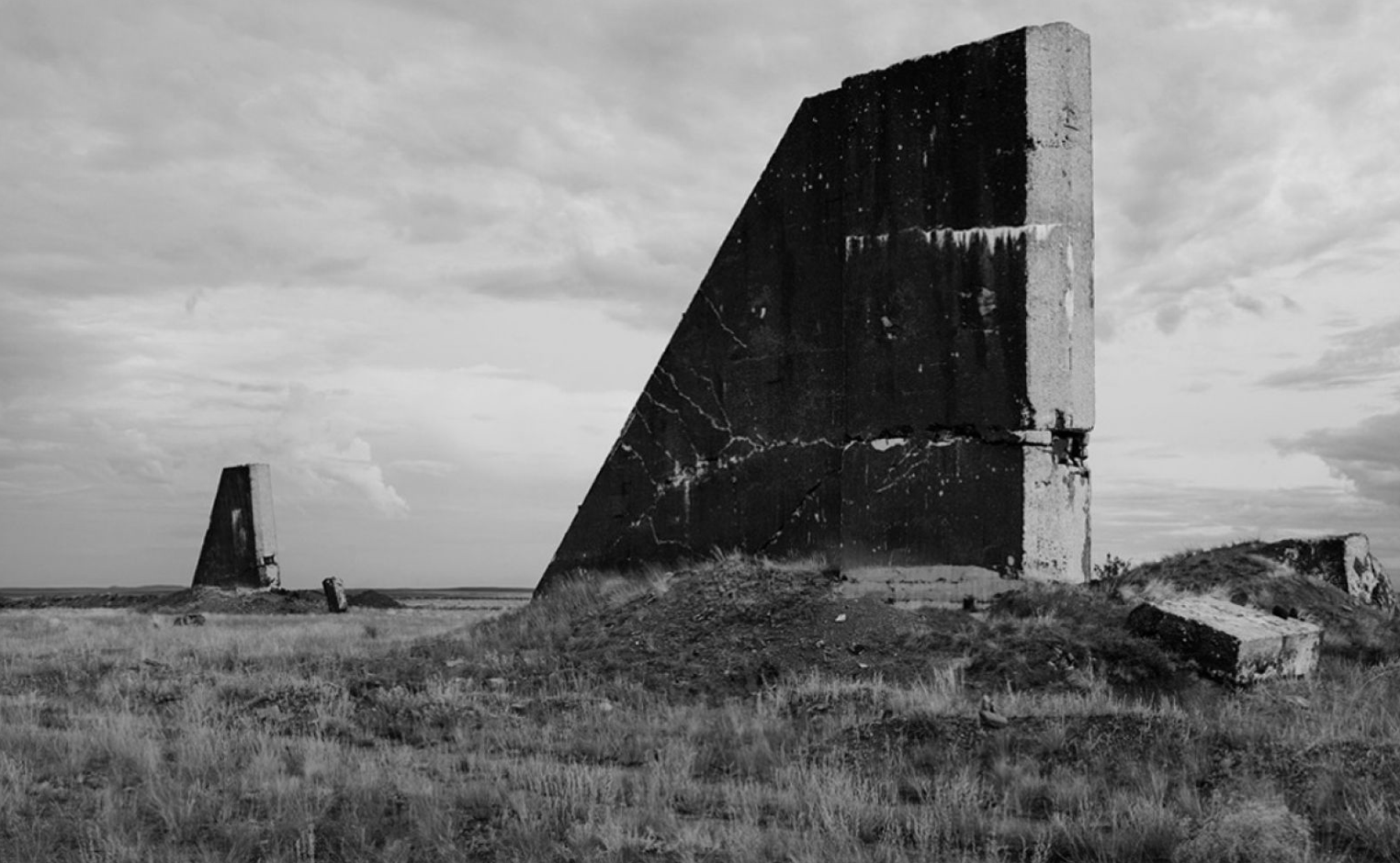
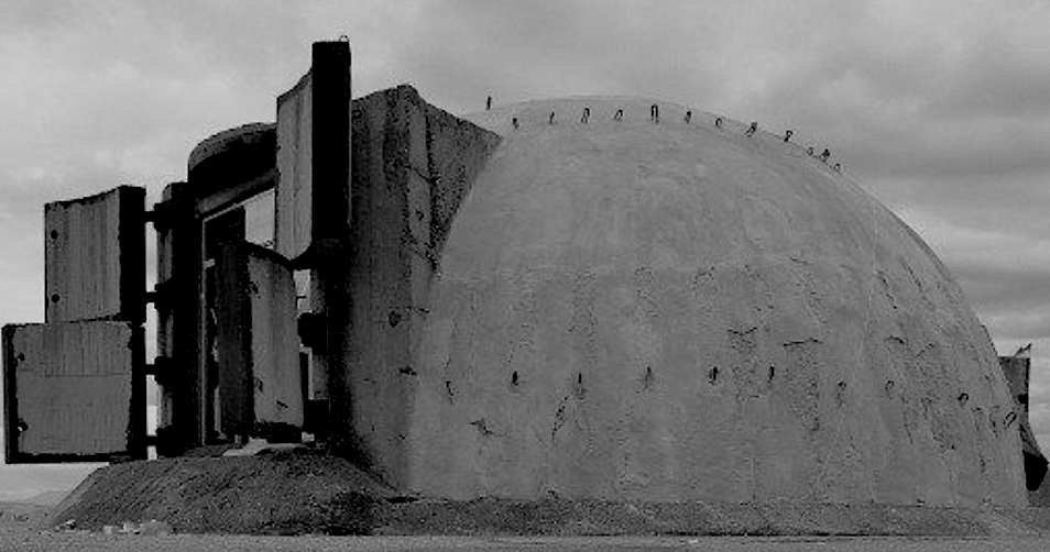
The Semipalatinsk Complex was of acute interest to foreign governments during its operation, particularly during the phase when explosions were carried out above ground at the experimental field. Several U-2 overflights examined preparations and weapons effects, before being replaced with satellite reconnaissance. The US Defense Intelligence Agency is said to have been convinced that the Soviets had constructed an enormous beam weapon station at a small research station located on the testing site.
This smaller research station, known to the Department of Defense as PNUTS (Possible Nuclear Underground Test Site) and the CIA as URDF-3 (Unidentified Research and Development Facility-3) was of great interest to American observers. After the fall of the Soviet Union in 1991, it was discovered that the mysterious URDF-3 was tasked with researching a nuclear thermal rocket similar to the US’s NERVA.
The site was closed by the President of the Kazakh Soviet Socialist Republic Nursultan Nazarbayev on 29 August 1991.
The Soviet Union conducted its last tests in 1989. After the Soviet Union collapsed in 1991, the site was neglected. Fissile material was left behind in mountain tunnels and bore holes, virtually unguarded and vulnerable to scavengers, rogue states, or potential terrorists. The secret cleanup of Semipalatinsk was made public in the 2010s.
After some of the tests, radioactive material remained on the now abandoned area, including significant amounts of plutonium. The risk that material might fall into the hands of scavengers or terrorists was considered one of the largest nuclear security threats since the collapse of the Soviet Union. The operation to address the problem involved, in part, pouring special concrete into test holes, to bind the waste plutonium. In other cases, horizontal mine test holes were sealed and the entrances covered over. Finally in October 2012, Kazakh, Russian, and American nuclear scientists and engineers celebrated the completion of a secret 17-year, $150 million operation to secure the plutonium in the tunnels of the mountains.
Large parts of the STS have opened up since 2014, and economic activity has resumed: mostly mining, but also agriculture and tourism. As with other areas affected by radioactivity, the lack of human interference has made the STS a haven for wildlife.
When the test site was closed, Kazakhstan was faced with the question of how to decontaminate the land and what to do with the military-industrial complex that remained on the territory of the test site.
In order to solve this and other problems, the National Nuclear Center was founded in Kurchatov City. Employees of the Center conduct research and carried out ‘re-cultivation’, which requires the land to be plowed in such a way that the contaminated topsoil ends up on the bottom, and the uncontaminated soil rises to the surface.
Curbing nuclear proliferation is the number one priority for Kazakhstan, which felt first-hand the impact of nuclear tests and voluntarily gave up its nuclear capacity. This country was one of the first CIS republics to join the Treaty on Non-Proliferation of Nuclear Weapons (NPT) and the Treaty on the Prohibition of Nuclear Weapons.
Kazakhstan also came forward with a proposal to create the International Day against Nuclear Tests, to be observed in order to promote the dissemination of information about the consequences of such tests. August 29 is not only the date of the first test at Semipalatinsk; on this date in 1991 President Nursultan Nazarbayev signed the decree closing the test site, also known as the Polygon.
EXCERPT FROM A REPORT BY THE INTERNATIONAL ATOMIC ENERGY AGENCY:
Various locations around the world are affected by residual radioactive material. Some of them are the result of past peaceful activities, while others result from military programmes, including the testing of nuclear weapons.
In the 1990s, there was growing international cooperation in assessing the radiological effects of past military nuclear activities. In many countries, attention has turned to assessing and, where necessary, remediating areas affected by residual radioactive materials from military activities. The IAEA [International Atomic Energy Agency] has been leading this effort of assessing former nuclear-weapon test sites. This article reports on preliminary radiological evaluations of the Semipalatinsk site in Kazakhstan, where the former Soviet Union conducted more than 400 nuclear tests over a forty year period.
THE SITE
The Republic of Kazakhstan is located immediately south of Russia, and west of China. Following World War II, the steppes of Kazakhstan became the first centre for nuclear weapons testing within the Soviet Union. The Semipalatinsk test site is a 19,000 km2 zone in the north- east of the country, 800 km north of the capital Almaty. The zone lies southwest of the Irtysh River which flows into Kazakhstan from China and which, for a short distance, forms part of the nuclear test site boundary.
During the period 1949-89 the former Soviet Union conducted about 460 nuclear weapons tests within the test site. They included explosions that were conducted on the surface or in the atmosphere. Five of these surface tests were not successful and resulted in the dispersion of plutonium in the environment. Starting in 1961, more than 300 test explosions were conducted underground. Thirteen of the underground tests resulted in release of radioactive gases to the atmosphere. (See table, below.)
The only on-site inhabitants during the testing programme were in the town of Kurchatov whose purpose was to service the site, and in the small settlements of Akzhar and Moldari along the northern edge of the site. Recently there has been a limited amount of resettlement within the area, mostly by semi-nomadic farmers and herders. The bulk of the local population is in settlements just outside the site border. The total population of these settlements is estimated to be 30,000 to 40,000 people.
IAEA MISSIONS
In May 1993, representatives of the Kazakhstan Government informed the IAEA of their concern about the radiological situation in Semipalatinsk and western areas. Subsequently, the Government of Kazakhstan requested the IAEA to provide assistance regarding the former test areas of Semipalatinsk and western Kazakhstan. The IAEA agreed to organize a study of the radiological situation in these areas. This commitment resulted in a series of activities to characterize and evaluate the radiological situation at the Semipalatinsk test site.
November 1993. The first IAEA mission was performed in November 1993. The objectives were to become familiar with the test site and provide guidance on future actions. The team was also asked to assist in strengthening the national infrastructure in the area of radiation protection, with emphasis on environmental monitoring.
The team traveled to the Semipalatinsk site and identified the most likely areas of radioactive contamination on the test site as well as off- site. It also performed limited radiation measurements and collected environmental samples at identified locations to assist in further defining the concerns and provide information as to future actions. The team also visited governmental laboratories to determine their capabilities for cooperative efforts and to locate existing radiological assessment data.
Based on the results of this first mission, IAEA officers met in March 1994 at Agency headquarters in Vienna with delegation from Kazakhstan. At this meeting, one topic of discussion was the concern about Semipalatinsk. In response to this concern, the IAEA agreed to establish, through its technical co- operation programme, a project to assist the Republic Kazakhstan in the radiological assessment of the Semipalatinsk test site.
July 1994.
A second IAEA mission to the test site was conducted in July 1994. The objectives were to collect additional radiological data from in and around the site, collect and review existing data provided by Russian and Kazakh sources relevant to the radiological situation at the test site, and to perform a prreliminary assessment of the present and potential future doses to residents in the Semipalatinsk area.
The goal was to determine whether further radiological evaluation and assessment were warranted. Soil, vegetable and milk samples were collected and analyzed by gamma spectroscopy and radiochemical analysis to determine radionuclide concentrations. Experts from the team spent time talking to inhabitants in the surrounding farms and settlements for the purpose of gaining information on the local diet and customs relevant to the dose assessment.
Duration of testing
1949-62 / 1961-89
1965-80/ 1968/ 1965-89
Test Zone Geology
Sandstone
Granite, quartz-porphyry, syenite rock mountain massif
Alevrolite, porphyry, sandstones Argyllite
Alevrolite, sandstones, conglomerate
Number of tests
Surface: 26 Air: 87
In mine galleries: 215 In boreholes: 24
In boreholes: 2
In boreholes: 107
IAEA BULLETIN, 40/4/1998
A third mission was conducted in 1998 in compliance with a United Nations General Assembly Resolution (52/169M). In this mission an expert team intensively examined the consequences and needs arising from two generations of nuclear testing in the territory of what has been the Republic of Kazakhstan since 1991. The mission was composed of specialists from organizations and agencies of the United Nations including the IAEA, the Government of Kazakhstan, and other technical experts from the international community. The mission was deployed from 15th – 30th June 1998 to carry out the needs assessment of the humanitarian situation in the Semipalatinsk Test Site Territory of Kazakhstan, as stipulated in the UN resolution.
FINDINGS OF THE MISSIONS
Based on information collected during the missions and subsequent research, there is sufficient evidence to indicate that most of the area has little or no residual radioactivity directly attributed to nuclear tests in Kazakhstan. There are a few areas that have elevated residual radioactivity levels within the test site where the surface tests were performed and where a few underground tests vented to the atmosphere. Preliminary surveys of these areas indicated that the contamination is relatively localised.
Due to the limited amount of survey data that was collected during the missions, the existence of actinide residues from the failed nuclear tests could not be corroborated. Descriptions of the nature of the failed tests, the prevailing conditions and any supporting data would be needed before further investigations are considered.
Currently there are no restrictions of access to the nuclear test site and limited reoccupation has already begun. An assessment of the exposure of persons who, on a daily base, visit the areas where the surface tests and vented underground explosions has been undertaken. Initial findings of this assessment indicate annual exposures in the region of 10 mSv, predominantly due to external exposure. If these areas were permanently settled in the future, estimated exposures could be up to 140 mSv per year. This annual exposure is above the action level at which intervention is expected to be undertaken. Remedial action is, therefore, considered necessary for these localized elevated areas. However, due to budgetary and other constraints, the most appropriate remedial action at this time may be to restrict access to these areas.
The measurements made by the IAEA experts corroborate, to a reasonable degree, the more extensive surveys carried out by different organizations from Kazakhstan and the former Soviet Union. The combined results are considered sufficient to form the basis of a preliminary assessment of the radiological situation of the area around the Semipalatinsk test site. The one exception to the above conclusion is the drinking water supply. While samples of drinking water taken during the missions showed no elevated levels of artificial radionuclides, sampling was not comprehensive. As such it is difficult to draw general conclusions about the entire water supply. In addition the results do not provide any guarantee about the future security of the water supply.
External dose rates. The external radiation dose rates and soil activity outside the test site are the same, or close to, typical levels in other regions and countries where no nuclear-weapons testing had been carried out. Some areas show small increases but these are not significant in terms of the exposure to the local population.
One village had a higher plutonium deposition level than the other settlements and has been the subject of more comprehensive soil sampling. However, estimated annual doses still remain low. Intervention to reduce the radiation exposure of people outside the Semipalatinsk test site is not considered to be justified.
this document will be revised and updated as new information becomes available.
